Date/Time
Date(s) - 15/05/2023
1:00 pm - 5:00 pm
Location
Bushuis F0.01
Categories
In collaboration with the CREATE Lab, University of Amsterdam
Date: Monday 15 May 2023
Time: 13:00 – 17:00 CET
Location: Bushuis F0.01, Kloveniersburgwal 48, 1012 CX Amsterdam
Registration: via Eventbrite
Introduction
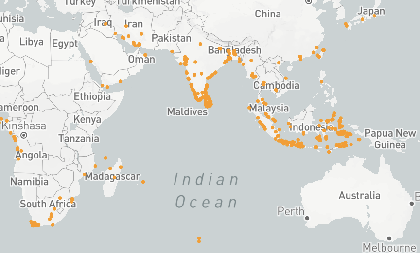
Historical places are important building blocks for the reconstruction of historical events. The GLOBALISE corpus of about 5 million pages from the VOC archives describes hundreds of thousands of events that took place over a period of two centuries in a large number of locations spread over a huge area around the Indian Ocean and Indonesian archipelago. Thanks to initiatives like the Atlas of Mutual Heritage and the World Historical Gazetteer, we can locate some of the places mentioned, but by no means all of them. Within GLOBALISE, we would like to bring as much of these locations to light as possible by creating a dataset that identifies and geolocates historical places mentioned in our texts. This is challenging, as disambiguation of spelling variations is not always easy, place names appear in different languages, change over time, and sources present ambiguous references to locations.
This datasprint aims to foster collaboration between historians, heritage professionals and data scientists for better availability of data on historical places. It intends to curate, publish, and link data on historical places collected by researchers within their own projects, as well as test and improve digital techniques to extract, structure, and share data on places. In addition to data creation, curation, and linking, this datasprint will offer a space to exchange knowledge and expertise on historical places and contexts, and digital techniques. We hope that by the end of the datasprint, all participants will have learned something, and that we will have generated valuable data on historical locations with which to improve our understanding of the early modern Indian Ocean and Indonesian archipelago worlds.
Sessions
The datasprint consists of three simultaneous sessions on georeferencing, data extraction, and data linking respectively. Everyone with an affinity or interest in (early modern) maps, history of the Indian Ocean World, or digital techniques for data extraction, is welcome to join regardless of technical / historical proficiency!
Georeferencing early modern maps
Chair: Jules Schoonman (TUDelft)
Preparation: None.
Tools: Your own laptop with an up-to-date browser (preferably Firefox or Chrome) with javascript enabled.
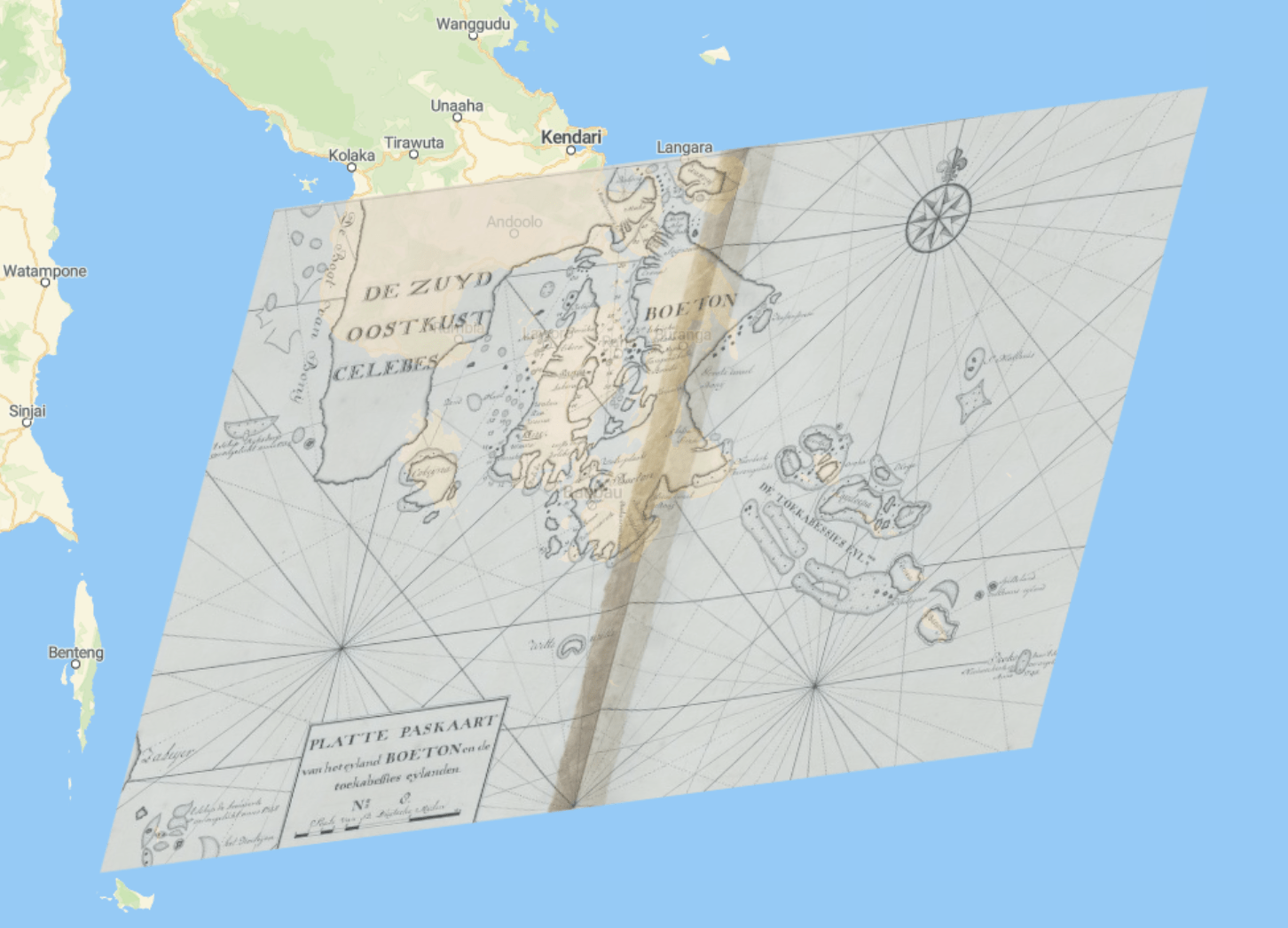
Digitised historical maps can be challenging to read and compare to modern-day maps, due to their difference in style, orientation, map projection and more. In these scenarios, it is helpful to georeference a map by relating several points to geospatial coordinates. On the basis of this information, the map can be used as an overlay in interactive web maps or GIS-applications, allowing for direct comparison between then and now. Other use cases include drawing geospatial data on the historical map or, conversely, the vectorisation of its features. Traditionally, such methods require the creation of derivatives, duplicate server infrastructures, and the use of proprietary software–often not resulting in open and reusable data.
This session introduces Allmaps, a new set of open-source tools to georeference, view and explore digitised maps from institutions supporting the International Image Interoperability Framework (IIIF). Using the sub-collection of maps from the Atlas of Mutual Heritage originating from the National Archives, we will (1) learn about IIIIF and how to find the right endpoints, (2) georeference maps in the Allmaps Editor, (3) learn about the format of a Georeference Annotation, (4) view the map in the Allmaps Viewer, (5) explore other uses for georeferenced maps.
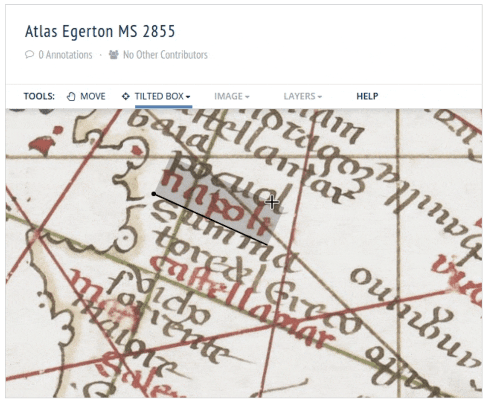
Data extraction from early modern maps
Chair: Melvin Wevers (UvA)
Preparation: None.
Tools: Your own laptop with an up-to-date browser (preferably Firefox or Chrome) with javascript enabled.
A substantial collection of historical location data for the Indian Ocean and Indonesian archipelago worlds is already available, notably in the Atlas of Mutual Heritage database that provides useful metadata for visual sources such as old maps. We aim to expand on this by, for instance, identifying locations and other geospatial features on a selection of old maps from the National Archives. In this session we will first try to identify the kind of information that can be extracted from old maps (e.g. inhabited places, but also, for example, plantations, mills, and harbours) to come up with an initial annotation framework, after which we will annotate these maps ourselves. The resulting data can be a starting point for automating the information extraction from old maps further.
Curating and linking new places data(sets) via World Historical Gazetteer
Chair: Rombert Stapel (IISG)
Preparation (optional): Bring your own data – a clean places dataset and access to your own dataset during session.
Tools: Your own laptop.
Do you have a finished or in-progress dataset on historical locations originating from your research or personal project and would you like to be able to geolocate these places and enrich your data with other historical data? In this session, we will work together to curate locations datasets to then upload them to the World Historical Gazetteer database and link them to other places in the WHG index – generating new, accessible, and reusable data on historical places.
Programme
13:00 Introduction
13:45 Breakout sessions: start
15:00 Break
15:15 Breakout sessions: wrapping up
16:00 Session results and conclusions
16:30 Reflection
17:00 Drinks